Ankalesvar Fm
Type Locality and Naming
Named after the township of Ankalesvar.
Lithology and Thickness
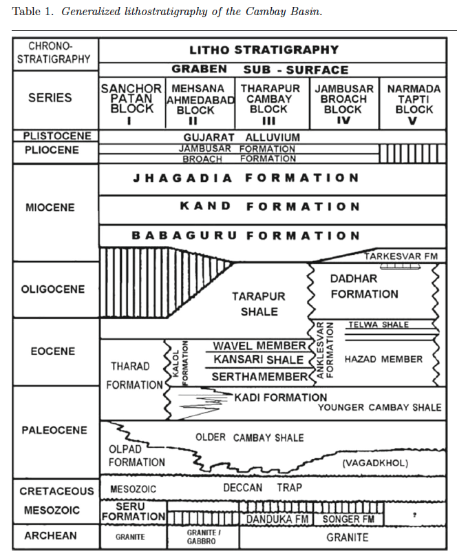
Clayey sandstone. Thickness is ca. 500 m. "Ankleshwar Formation of Mid to Late Eocene age overlies the Cambay shale. It contains of two arenaceous members, viz., Hazad and Ardol, separated by Kanwa Shale Member. The Hazad Member of Ankleshwar Formation has been a prolific producer of hydrocarbon in this basin ... The younger Ardol Member is overlain by the Telwa Shale Member. Ankleshwar Formation is overlain by arenaceous Dadhar Formation of Oligocene age." (from Bhumija Agarwal et al., 2013, https://spgindia.org/10_biennial_form/P221.pdf). "Across the oil fields of the Cambay Basin,
sandstones within the Hazad Member are some of the most prolific producing horizons" (from Jaiswal and Bhattacharya, 2018, J.EarthSyst.Sci., 127:65) [NOTE by J.Ogg – See "Additional Information" about an apparent duplication in the file submitted for upload. Therefore, I have inserted descriptions from other articles on this formation.]
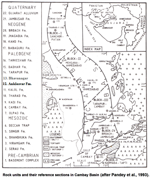
[Figure 1: Rock units and their reference sections in Cambay Basin (after Pandey et al., 1993)]
[Figure 2: Generalized stratigraphy of the Cambay Basin. (from Jaiswal and Bhattacharya, 2018, J.EarthSyst.Sci., 127:65)]
Relationships and Distribution
Lower contact
The formation is conformably overlain by Dadhar Fm.
Upper contact
Unconformably underlain by Cambay Fm Shale
Regional extent
The formation is developed in South Cambay Basin in Jambusar-Broach and Narmada-Tapti blocks.
GeoJSON
Fossils
Age
Depositional setting
Additional Information
[Figure 1: Rock units and their reference sections in Cambay Basin (after Pandey et al., 1993)]
[Figure 2: Generalized stratigraphy of the Cambay Basin. (from Jaiswal and Bhattacharya, 2018, J.EarthSyst.Sci., 127:65)]
Lithology-pattern: Clayey sandstone
Relationships and Distribution:
Lower contact:
The formation is conformably overlain by Dadhar Fm.
Upper contact:
Unconformably underlain by Cambay Fm Shale
Regional extent:
The formation is developed in South Cambay Basin in Jambusar-Broach and Narmada-Tapti blocks.
GeoJSON:
{ "type": "Feature", "properties": { "NAME": "Cambay Basin" }, "geometry": { "type": "MultiPolygon", "coordinates": [ [ [ [ 71.47, 24.96 ], [ 72.04, 25.03 ], [ 72.95, 23.89 ], [ 73.42, 22.76 ], [ 73.38, 22.06 ], [ 72.46, 21.01 ], [ 71.47, 24.96 ] ] ] ] } }
Fossils:
Age:
Middle to Upper Eocene age is assigned based on palynofossils.
Age span:
Beginning stage: Lutetian
Fraction up in beginning stage: 0.1
Beginning date (Ma):
Ending stage: Priabonian
Fraction up in ending stage: 1.0
Ending date (Ma):
Depositional setting:
"The Hazad Member (Middle Eocene) of the Ankleswar Formation in Cambay Basin, India, is traditionally reported as deltaic system. Present work documents three major facies associations, namely, (i) sandstone-rich upper delta plain (FA-1) deposits, (ii) sandstone-mudstone heterolithic lower delta plain–delta front (FA-2) deposits, and (iii) shale-dominated prodelta (FA-3) deposits, in an overall coarsening-up to fining-up succession." (from Jaiswal and Bhattacharya, 2018, J.EarthSyst.Sci., 127:65)
Depositional pattern:
Additional Information
[NOTE by J.Ogg – Below is what I was provided originally. However, this set of lithology description, reference-well interval and thickness, fossils and depositional setting is identical for that of Bhavangar Fm of similar age; so maybe the provided source-compilation accidentally copy-pasted that formation? Therefore, I have inserted descriptions from other articles on this formation?]
Location -- Well Gulf-1, (depth interval 1891-2012 m). It is of 121 m thickness. [Original Publication: Rao, K.L.N. (1969) Lithostratigraphy of the Paleogene succession of southern Cambay Basin, ONGC Bull, vol 6 (1), pp. 24-37] Reference well: Well Gulf-2 (depth interval 1652 – 1780 m), it is of 128 m thickness.
Lithology -- Sandy claystone. The type section includes grey shale, sandstone and ferruginous sandy claystone. The shales are intercalated with sideritic mudstone and sandy mudstone and sandstone. The sandstone is hard, coarse to very coarse grained. The thickness of the formation is 121 m in Gulf-1
Fossils -- The formation is poorly fossiliferous, includes: palynofossils Polybrevicolporites cephalus, Plygalacidlites clarus, Pellicieroiporites sp., and P. langenheimii
Depositional setting -- Lower part of the formation is deposited in low energy environment; upper part is interpreted to have been deposited in high-energy environment in a fluvial setting. Overall, the upper part indicates deposition in near shore fluctuating energy conditions

